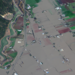
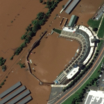
Maxar collected new satellite imagery on Friday (November 19th) of the ongoing flooding in Sumas Prairie to the east of Abbotsford, British Columbia, Canada. Highways, roads and many buildings and farms remain under water.
Maxar Satellite Imagery: Flooding in New Jersey
Maxar collected new high resolution satellite imagery yesterday (September 2nd at 11:52 AM, Eastern) that shows historic flooding along the Raritan River in New Jersey. As the remnants of Hurricane Ida moved through the northeast of the United States, the storm dropped record-breaking rainfall causing floods and damage in multiple towns and communities including Somerville, Manville, […]
Maxar Technologies collected new satellite imagery of Davenport, Iowa flooding caused by the Mississippi River
Maxar Technologies collected new satellite imagery yesterday, May 4, 2019, of Davenport, Iowa and the downtown flooding caused by the Mississippi River
DigitalGlobe Satellite Imagery: Flooding in U.S. Midwest
DigitalGlobe’s WorldView-2 satellite collected new imagery March 18, 2019 of the historic flooding of the Missouri and Platte rivers south of Omaha, Nebraska.
Neptune Flood Expands Coverage to Six Additional States
First Fully Online Flood Insurance with Up-To-The-Minute Mapping of Flood Risk Now Available in 27 States
Panoramic Imagery for Canyon Gate Subdivision, Fort Bend County, Texas
An update from Fort Bend County, Texas and their recent use of Esri Startup company, GroundVu, for obtaining 3D imagery of flood areas.
High-Resolution Flood Imagery on Website, App Today to Assist Houston Relief Efforts
The before-and-after imagery slider on Woolpert’s website allows local, state and federal officials and the public to navigate and enhance sites in Houston in the wake of Hurricane Harvey.
New Warning System Identifies Flash Drought Quickly
Agricultural crops can wither in a flash when the days turn hot, the air dries, the rain stops and moisture evaporates quickly from the soil. A new early warning system can help alert managers and others as drought begins to happen.
Twitter feed and map provide real-time water, weather and flood forecasting for Texas
(via the USGS) Flood Preparedness – There’s a New USGS Map (or App) for That — An innovative Twitter feed and map provide real-time water, weather and flood forecasting for Texas.
Houston flooding could cost up to $1.9 billion – costliest flooding in 15 years
Houston flooding could cost up to $1.9 billion, BBVA Compass economists say – It’s the costliest flooding the city has seen in 15 years, they say


