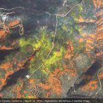
DigitalGlobe collected a new set of images yesterday (March 19th) of the “Superbloom” near Lake Elsinore, California. The colorful satellite imagery shows the hillsides along Walker Canyon filled with blooming poppies as well as hundreds of cars parked nearby and people hiking along trails in the area.
DigitalGlobe Satellite Imagery: Flooding in U.S. Midwest
DigitalGlobe’s WorldView-2 satellite collected new imagery March 18, 2019 of the historic flooding of the Missouri and Platte rivers south of Omaha, Nebraska.
Satellite Imagery: Hurricane Michael Aftermath in Panama City and Tyndall AFB
DigitalGlobe’s WorldView-1 satellite collected new imagery on October 11th of Panama City and Tyndall Air Force Base (AFB), Florida.
DigitalGlobe Satellite Reveals Imagery of Russian Military Exercise (Vostok 2018)
Two of DigitalGlobe’s high-resolution imaging satellites (GeoEye-1 and WorldView-3) collected new imagery this morning, September 13, 2018, of the large Russian military exercise (known as Vostok 2018) being conducted at the Tsugol training area in eastern Russia.
Maxar Technologies’ DigitalGlobe Expands Agreements with Two Major Commercial Technology Customers
Maxar Technologies’ DigitalGlobe Expands Agreements with Two Major Commercial Technology Customers, Extending Its Leadership Position in High-Resolution Satellite Imagery
DigitalGlobe Releases High-Resolution Satellite Images of the Northern California Wildfires
Today DigitalGlobe released high-resolution satellite images of the wildfires burning in Northern California. These wildfires have killed at least 21 people, destroyed at least 3,500 structures, and burned more than 115,000 acres. In the above link, you’ll find imagery of the Santa Rosa, Calif., area taken yesterday and today.
DigitalGlobe Releases High-Resolution Satellite Images of Mexico City
Today DigitalGlobe released high-resolution satellite images that show the damage inflicted by the Sept. 19 earthquake in Mexico City.
Satellite Imagery: DigitalGlobe Releases High-Resolution Satellite Images of Hurricane Irma Damage
As Hurricane Irma churned through the Caribbean and up Florida’s coast, DigitalGlobe’s satellites have been capturing high-resolution images of the storm’s damage. Imaging in the Caribbean became possible over the weekend as the clouds moved out of the area.
DigitalGlobe Announces Four-Year Direct Access Contract with the Australian Department of Defence
DigitalGlobe Announces Four-Year Direct Access Contract with the Australian Department of Defence for Real-time Access to the World’s Highest-Resolution Commercial Satellite Imagery
DigitalGlobe Announces Launch of SecureWatch
DigitalGlobe Announces Launch of SecureWatch™, Advancing Mission Preparedness and Success When Decisions Matter Most


