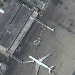
Maxar collected new high-resolution satellite imagery this morning (10:36 AM local time, 16 August) of the chaotic scene underway at Kabul’s Hamid Karzai International Airport in Afghanistan as thousands of people converged on the tarmac and airport runways as countries attempt to evacuate personnel from the city.
DATAMARK SPONSORING AND EXHIBITING AT 2021 NENA CONFERENCE
WHO: DATAMARK, the public safety GIS team of Michael Baker International. As trusted advisors in public safety, DATAMARK brings comprehensive, real-world expertise in police, fire, EMS and 9-1-1 leadership roles to Next Generation 9-1-1 transitions. The DATAMARK team leads the industry by shaping rules and legislation, and by building a suite of products and services that ensure […]
Maxar Satellite Imagery: Miami Building Collapse, Before and After
Maxar collected new satellite imagery this morning (11:40 AM, Eastern; June 25th) of the collapsed Champlain Towers South condo complex in Surfside, Florida. Dozens of rescue vehicles can be seen around the collapsed building as search and recovery efforts continue throughout the day.
UCL Virus Watch Study tracks location of volunteers to help understand behaviour during Covid-19 pandemic
Real-time location data used to examine people’s mobility after a single vaccination
Northamptonshire Fire and Rescue Service adopts GIS software for risk analysis
Cadcorp SIS Desktop, Workload Modeller and Risk Modeller selected for fire service resource and risk planning
NOAA predicts another active Atlantic hurricane season
May 20, 2021 – NOAA’s Climate Prediction Center is predicting another above-normal Atlantic hurricane season. Forecasters predict a 60% chance of an above-normal season, a 30% chance of a near-normal season, and a 10% chance of a below-normal season. However, experts do not anticipate the historic level of storm activity seen in 2020.
British Red Cross turns to digital mapping to help meet increased demand for support due to Covid-19
18 May 2021 – The British Red Cross has created new mapping tools using Esri GIS, which are being used by the Voluntary and Community Sector Emergencies Partnership (VCSEP) and its network of over 250 organisations, to improve collaboration as it responds to the Covid-19 crisis.
Maxar Satellite Imagery: Train Derailment in Mexico City
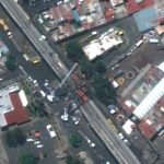
Maxar collected new satellite imagery (May 4, 2021) of the aftermath of the passenger train derailment that occurred on Monday night in southeastern Mexico City. According to media reports, a passenger train traveling along an elevated track derailed after a concrete overpass collapsed. At least 23 people were killed and 80 others were injured. In […]
New Personal and Public Safety App Keeps Users Safer
In Case Of Emergency, Activate Safe4r App
Mark Zuckerberg Announces Facebook’s Plans To Help Get People Vaccinated Against COVID-19
MENLO PARK, Calif., March 15, 2021 /PRNewswire/ — Mark Zuckerberg, Facebook founder and CEO, today announced that Facebook, Inc. (Nasdaq: FB) plans to help people get vaccinated against the COVID-19 virus.


