The annual International Esri User Conference is ESRI’s chance to discuss, demonstrate, and showcase their latest technologies and educate the user community about all the latest innovations from their product design teams.
So, what resonated with me this year at UC? There was plenty, including updates to ESRIC’s core technologies including ArcGIS Online, Story Maps, and data collection solutions. With that, here’s a quick look at some of the new capabilities and updates rolled out just in time for UC.
Story maps
One unified story builder, meaning no decisions needed regarding templates
There is now a new generation of story maps technology… ArcGIS story maps. Users will now find one unified story builder, meaning no decisions needed regarding templates. The new Story Maps technology is completely cloud-based, totally browser-based, a mobile-first experience, and no coding is necessary! Esri wants users to tell your story and make your maps come alive. We saw numerous examples of amazing story maps, including a number of references to the non-profit user community (for example, Jane Goodall Institute) and how they can tell their stories. For this user segment there are many benefits including the ability to share:
- Why they do what they do
- Turn their PDFs into a more rich experience
- Sharing project impact or success
- Celebrate the people behind your organization
Learn more about the “new” Story Map technology https://www.esri.com/about/newsroom/arcnews/arcgis-storymaps-the-next-generation-of-map-based-storytelling/
Recall, when the new story maps Beta came out, we put it to the test and shared in this article.
Quick Capture
Quick Capture is a new solution designed specifically for “rapid data collection”. The application designed using the “mobile-first” mindset, is for those users who are on the go (literally, like in a moving vehicle) and need a simple to use, quick and efficient way to capture data and attributes. The dev team shared that so far, the app is typically used while on the go, it can function in offline mode, provides a WYSIWYG experience and supports the use of your existing feature layers. Quick Capture boasts a simple, single-touch data capture experience that should appeal to a wide audience! Getting started is easy. Simply visit this link (https://www.arcgis.com/apps/quickcapture/projects) and click the Launch button (upper right) – You will need AGOL access as well as some licensing privileges. You can create an ArcGIS QuickCapture project from one or more existing feature
ArcGIS Online
ArcGIS Online is an integral part of Esri’s Geospatial Cloud, enabling users to access a wealth of data, build custom apps, and even use analytical tools to create dynamic webmaps and web apps. AGOL receives regular updates and the list of features and specs is constantly growing. Most recently, the latest major update was rolled out in June, just prior to ESRIUC. Some noteworthy enhancements that were the topic of conversation at UC include, the ability to customize the style of vector tile layers (think, create your own, custom basemaps) – learn more at https://onlinelabs.maps.arcgis.com/home/group.html?id=20dd19496c504cbf999c408014f88353#overview. Some other noteworthy enhancements include more map symbols (particularly for utilities), enhanced administrative options for configuring users, user accounts and roles. I thought something very cool is the ability to now simply draw a polygon around features to determine which data will be available for use in offline maps. Finally, myself being from the non-coder World, I’m a fan of configurable apps – template apps that are easily configured, customized, and launched. Now there are even more configurable app templates that open up the World of custom app development to everyone. Learn more about AGOL and the June update in this blog post https://www.esri.com/arcgis-blog/products/arcgis-online/announcements/whats-new-arcgis-online-june-2019/
A few items on the ArcGIS Online “Road Ahead” list:
- Building more on JSAPI4
- Accessibility first, clean UI design, more internationalization
- New, redesigned popups – dockable
- Group layer possibility
- Multi-line labeling
- Form-based editing
- Quickly explore and change color ramp styles…
- More collaboration support for between orgs
- Bulk actions for member mgmt
- Arcgis analytics for IOT
- More places – POIs
- Fall release coming in September
ESRIUC is also a gathering of Esri business partners and solution providers. More than 200 partner companies were exhibiting and sharing their solutions. Some of the highlights of technologies (and my personal faves) shared included:
Maptiks from Sparkgeo – Available to the ArcGIS user community via the Marketplace, Maptiks brings analytics to authors of webmaps and webmap services, giving developers access to insights and details of how your customers and visitors are interacting with your maps. Maptiks also supports Google maps, Leaflet, Mapbox, Mango, and more!
ikeGPS – At UC, the award-winning business partner was demoing the latest features from Spike’s integration with Esri’s Survey123 for ArcGIS. This integrated solution is designed for the novice to intermediate user, so you can train anybody to go into the field and capture the data you need to complete your project on time and on budget. Common applications include transportation, code compliance, sign inventory, asset management, and tax assessments.
Epson Moverio smart glasses – I have to admit, I didn’t realize Epson was in this space but was pleasantly surprised! The company was showing off the Moverio BT-300 smart glasses – an augmented reality solution designed for UAV pilots and other mapping professionals. Using the glasses, any UAV pro can operate their flight mission using an AR heads-up flight experience. The company also shared how the glases are useful for aerial photography and videography applications.
Trimble reps were showing off the TDC600 handheld, a next-gen smartphone and GIS data collector. Equally impressive, the company was also sharing how Trimble SiteVision can work directly with data from ArcGIS to create precise outdoor augmented reality viewing experiences to increase collaboration and improve decision-making. Site Vision uses Trimble’s Catalyst softGNSS receiver, combined with Google ARCore technology – This hardware solution was really COOL!
The Half-Earth Project – this amazing project comes from E.O. Wilson and is mapping the Earth’s species at a very fine scale. The goal is to identify conservation priorities in order to protect endangered species. Half Earth is a call to protect half the land and half the sea to better manage and protect precious habitat.
Mapillary – The Mapillary team (about 6 of them) were exhibiting and sharing how users all over the planet have been using their technology to capture, host and share street-level imagery. Of interest is the growing number of local governments and other official agencies that have adopted Mapillary as a solution. They’ve shared a recap of ESRIUC on their blog, be sure to check it out.
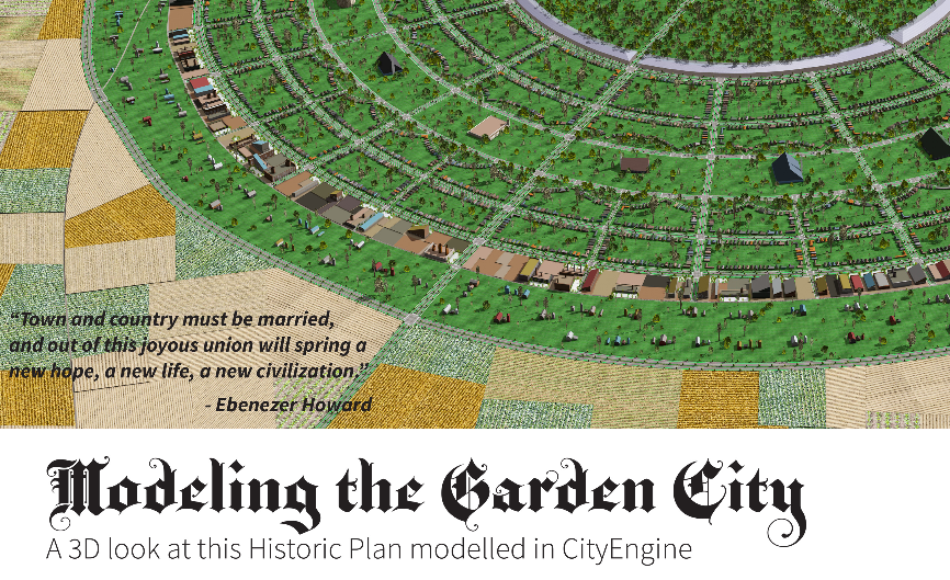
Houseal Lavigne – Hopefully you heard about this Chicago-based company while at UC, if not, I’m sure you will in the future! HL is a geospatial & GIS consulting firm that specializes in architectural design, urban planning, and amazing 3D data visualizations. The team had an award-winning map in the map gallery that wow’d many attendees and was at the conference to share that they are not only experts in 3D renderings and the urban planning place, but they are also extremely talented when it comes to custom GIS solutions, Esri business analyst solutions, ArcGIS Urban for municipal clients, and they are also skilled at ArcGIS Hub deployments! Be sure to check out their winning map – Modeling the Garden City
More ESRIUC related topics and news:
Esri Honors Organizations for Exceptional Use of Geospatial Technology


