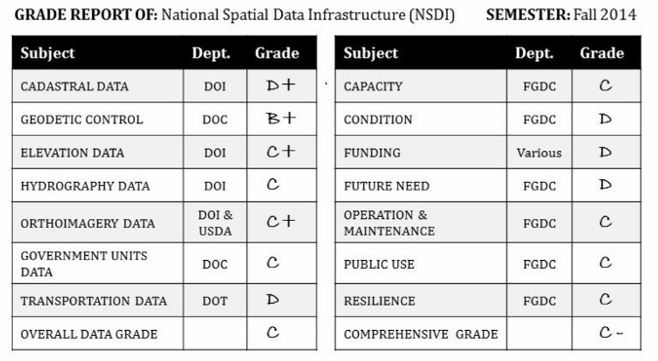
WASHINGTON, DC – At a news briefing on Monday, former Wyoming Governor James Geringer will highlight the Coalition of Geospatial Organizations’ (COGO) Report Card on the U.S. National Spatial Data Infrastructure (NSDI) released on February 6, 2015.
The Report Card describes the condition of the nation’s information about roads, water, land, air, bridges, dams, topography, and more. The NSDI Report Card highlights the poor condition of the nation’s information about our infrastructure at a time when the National Governors Association Chair, Governor Hickenlooper of Colorado, is calling on states to lead the way in “Delivering Results” on government promises. This information is critical to achieving the NGA Chair’s initiative. States will use the best information available, but the Report Card encourages government agencies to improve the national spatial data infrastructure to better support efficient government operations at all levels.
Geringer, Chair of the Panel that drafted the Report Card for COGO states, “The goal of the Report Card evaluation is to bring attention to the need for current and accurate geospatial data for the nation.
Governor Hickenlooper’s “Delivering Results” initiative with the National Governors Association is dependent on this information to make state governments work in the most efficient, cost-effective way possible.”
Former Governor Geringer goes on to say, “Government agencies at every level are dependent on this data, as are private sector businesses. The Report Card is the first of a series of periodic report cards by COGO. We did not include cost estimates for completing the NSDI or bringing it to a specified level. We need State and Federal government to make improvement of the NSDI a high priority so the nation can make significant, rapid progress on jobs, education, economic growth, public safety, energy, natural resource management, health care, agriculture, transportation and other areas. This information will also allow us to track and manage our progress in all these areas, reducing duplication and ensuring sustainability of our efforts over time.”
On a daily basis, most people encounter and understand the need for maintenance of the nation’s roads, bridges, dams, power lines, pipelines, telecommunications network, and all the rest of our physical infrastructure. The local, state and federal government agencies along with private companies that maintain the infrastructure must know where maintenance is needed, when it’s needed, and what needs to be done to plan it out in the most cost effective manner. There are millions of miles of roads, pipelines, and the like to maintain. That means a lot of information is needed and that information must be accurate and up-to-date.
In addition to maintenance, accurate and up-to-date information about the nation’s infrastructure is absolutely essential for all kinds of other activities including:
· getting ambulances to emergencies faster and evacuating people in the path of natural disasters
· monitoring and treating public health and environmental issues
· responding to the need for jobs, health care, foster homes, and other social services
· planning the location of schools, shelters, retail stores, and promoting economic growth
· managing traffic flow, and expansion of mass transit and utilities …and much more
The COGO member organizations represent approximately 170,000 professionals who develop and use spatial information about the nation’s physical infrastructure. The Coalition is delivering this assessment to help Congress, the Administration, Federal agency executives, and others understand the importance of geospatial data to the nation, as well as shortcomings of the NSDI. The member organizations want to engage Congress and Federal agencies to discuss and identify common sense improvements that will lead to a more robust NSDI.
You can find the Report Card on the U.S. National Spatial Data Infrastructure (NSDI) at http://cogo.pro/
COGO Member Organizations American Society of Civil Engineers (ASCE) American Society for Photogrammetry and Remote Sensing (ASPRS) Association of American Geographers (AAG) Cartography and Geographic Information Society (CaGIS) Geographic and Land Information Society (GLIS) Geographic Information Systems Certification Institute (GISCI) International Association of Assessing Officers (IAAO) Management Association for Private Photogrammetric Surveyors (MAPPS) National Society of Professional Surveyors (NSPS) National States Geographic Information Council (NSGIC) United States Geospatial Intelligence Foundation (USGIF) University Consortium for Geographic Information Science (UCGIS) Urban Regional Information Systems Association (URISA) www.cogo.pro

